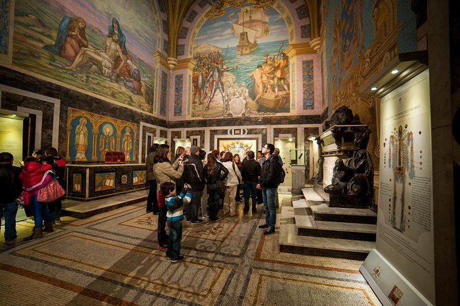
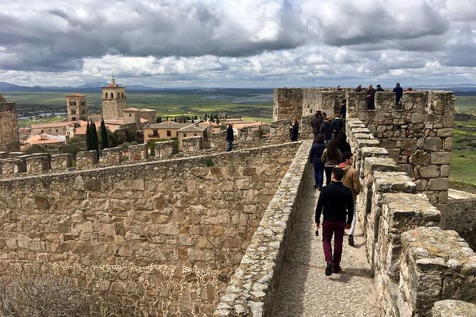
separador

www.welcomeperutravel.com

Agencia de Viajes Welcome Peru Travel
Welcome Peru Travel - Travel Agency - Tour Operator

separadorEnglish | Espaņol

| History of Peru | Peru Tours | Tourism in Peru | Hotels |
| Useful information | Biodiversity |

Welcome Peru Travel - Mapsite | info@welcomeperutravel.com| www.welcomeperutravel.com | Imagenes, Turismo Peru, Aventuraseparador


> Welcome Peru

separador

> About us

separador

> Useful Information

separador

> Map of Peru

separador

> Sitemap

separador

> Tourism in Peru

separador

Lima
Historic Center
Caral
Cusco
Machu Picchu
Inca Trail
Salcantay
Choquequirao
Puno
Titicaca Lake
Arequipa
Colca Canyon
Nazca
Nazca Lines
Paracas Reserve
Ballestas Islands
Chan Chan
Sipan Lord
Puerto Maldonado
Manu
Tambopata
Candamo
Iquitos
Pacaya Samiria
Tarapoto
Huaraz

separador

PERU TOURS
Packages Tourist

separador

HOTELS
IN PERU

separador

> Transport

Air Transport
Land Transport
- Trains
- Buses

separador
Galeria Fotos Peru, Imagenes Peru

Photo Gallery

separador
Calendario Turistico Peru, Fiestas, Costumbres, Regiones Peru

Tourist Calendar

separador

Clima del Peru, Regiones Peru, Costa Peru, Sierra Peru, Selva Peru
separador
Noticias Peru, Turismo, Actualidad Turistica
separador

Terms and
Conditions

separador

Testimonial


To: Gisella Rojas From: Nora….
Date: Friday, November 26th, 2004
at 07.28 a.m.
Re. Nora Perdomo Dear Guisella Just a few lines to thank you for the excellent service you provide us. Your representatives in Cuzco were just great. We are going to give our best recommendations about you. It is a shame we couldn’t spend more time in Cuzco, but it may be an excuse to go back again. Thanks for everything


Read +


separador
separador

Red Vial


The Inca Trail

The work which allowed Inca territorial expansion and later socioeconomic organization was without a doubt the vast road network which included bridges, tambos and warehouses. Few nations in the sixteenth century could have boasted of possessing such a fantastic road complex as Tahuantinsuyo.
Roads were not an Inca invention, they must have existed a long time before to join the different ethnic groups, to perform pilgrimages to the main sanctuaries or huacas and take care of exchanges between the seņorios.

Surely the Wari hegemony had roads to all the limits reached by their domains and they were indispensable to maintain their political organization. Likewise, the Chimu whose dominions took in a wide zone of the north coast, used routes presently recognized by archaeologists.

Nevertheless, traffic was not allowed for everyone in every moment. In the report on Chincha the frequent state of war existing between the seņorios is mentioned, a situation which prevented free circulation without the authorization of the curacas. The routes remained free when truces were established which surely coincided with religious ceremonies for the most important huacas.
With the rise of Tahuantinsuyo the number of roads increased until they reached an extraordinary magnitude. According to the estimations of Hyslop, the road system included 30 to 50 thousand kilometers in its totality. The merit of the Inca consisted in planning the labor force which executed the network of roads which would be the base of the state infrastructure. However, as the irony of fate would have it, the roads facilitated the followers of Pizarro in their conquest of the Andean state.
The Inca government needed the routes to move their armies, to send the mitimaes to distant places where they were needed, and also to send administrators, judges and inspectors to the farthest towns. Therefore the road network responded to all the exclusive aims of the central government and not the particular ethnicities. That is the basic point which distinguishes the Andean system from modern routes of communication.

There were two trunk roads, one extended the length of the highlands from south to north and the second joined the coastal valleys to each other. Between the two regions, other roads connected the principal ones.

There is not a single pattern given for the Inca routes. They adapted to the geography of the zone. In the coastal valleys, mud walls bordered the roads and singing canals offered water to travelers. Moreover, leafy trees gave their shade. In the deserts, stones or trunks of trees marked the route so travelers could avoid getting lost. In the highlands some roads were cobbled and fenced by stones, while steps climbed the rough slopes. On precipices, some parapets protected travelers and packs of camelids so they would not fall into the abyss.


Subir


Bridges
Various types of bridges crossed the rivers. In the highlands there were tree trunks when the distances were not great and the ones which became famous for their ingenuity were the ones the Spanish called "braided". These bridges were supported on two great abutments of stone with strong, solid foundations and in between each abutment crossed four or six thick beams which moored the hanging bridge. The thick ropes were woven of thin branches like wicker, braiding three by three into other, thicker ones, the branches getting bigger until they reached a diameter of some fifty centimeters. A reference in 1534 describes one of these bridges as follows: "There are great and powerful rivers over which there are bridges of thick cords and between one and another there are delicate and minute cords; and of these bridges there are two over which the lords pass and two over which pass the common people."

The same report adds that at each side of the bridge there were people who lived in the place whose job consisted of taking care of it and mending the worn out cords.

Another way to cross a river was with a "hanging basket". Cobo describes it as a thick rope made out of reeds, thick as a leg, which was tied to crags or abutments from one bank to the other. From this rope hung a basket with an arched handle through which the rope passed. In the canasta the person was seated and with a rope tied to the basket they pulled from one end.

In the south, on the Desaguadero near Lake Titicaca, there was a famous bridge which consisted of a row of totora rafts arranged side by side with a thick layer of bulrushes added and arranged over the vessels.

Subir


Vessels 
The Spanish made famous their narratives about the tambos or inns situated at certain intervals along the routes. It is possible the tambos existed in earlier times for lodging pilgrims on routes which led to pilgrimage sites. Possibly also they were used in the epoch of Wari and Chimu. They were of different categories and dimensions according to their importance.

Along the main routes there were chambers for lodging the Inca when he left Cuzco, whether to visit his states or march to war. There were also lesser tambos to lodge administrative personages which were being moved for various reasons. The very small ones were reserved for the messengers or chasqui who carried the news through the extensive territory.

In viceregal times Inca tambos were used and there were two lists of these inns from Cuzco, The City of the Kings, and Quito. According to Hyslop, there was difficulty recognizing a tambo on the ground because their architecture varied and it is possible the habits and customs of the local labor force influenced their construction


Subir


separador


Peru Tours | Tourism in Peru
Contact us | Term and Conditions


Lima | Historic Center | Caral | Cusco | Machu Picchu | Inca Trail | Salcantay | Choquequirao | Puno
Titicaca Lake
| Arequipa | Colca Canyon | Nazca Lines | Nazca | Paracas Reserve | Ballestas Islands
Sipan Lord | Puerto Maldonado | Manu | Tambopata| Candamo | Iquitos | Pacaya Samiria | Tarapoto | Huaraz

Recurses 1 - 2 - 3 - 4 - 5

Welcome Peru Travel - Lima  | Reserved Rights
Calle Sta. Felicidad 270 - 2do piso Urb. Pando 3ra etapa . Cercado de Lima - Peru
info@welcomeperutravel.com | www.welcomeperutravel.com | Telefonos (51-1) 564-5710